During the gold rush, San Francisco was literally built on top of abandoned ships, as its waterfront was extended out into the Bay. The above map, part of the SFgenealogy site’s section on buried ships, shows the position of those ships. More at UpOut. [Michael Kodysz]
Tag: cities
Typographic Map of San Francisco
Axis Maps updated their typographic map of San Francisco last month, with bodies of water, beaches and parks seeing changes. Prints are already sold out are sold out in the UK store but still available in the U.S.; but we can still appreciate the design. [Andy Woodruff]
Earlier blog posts about typographic maps.
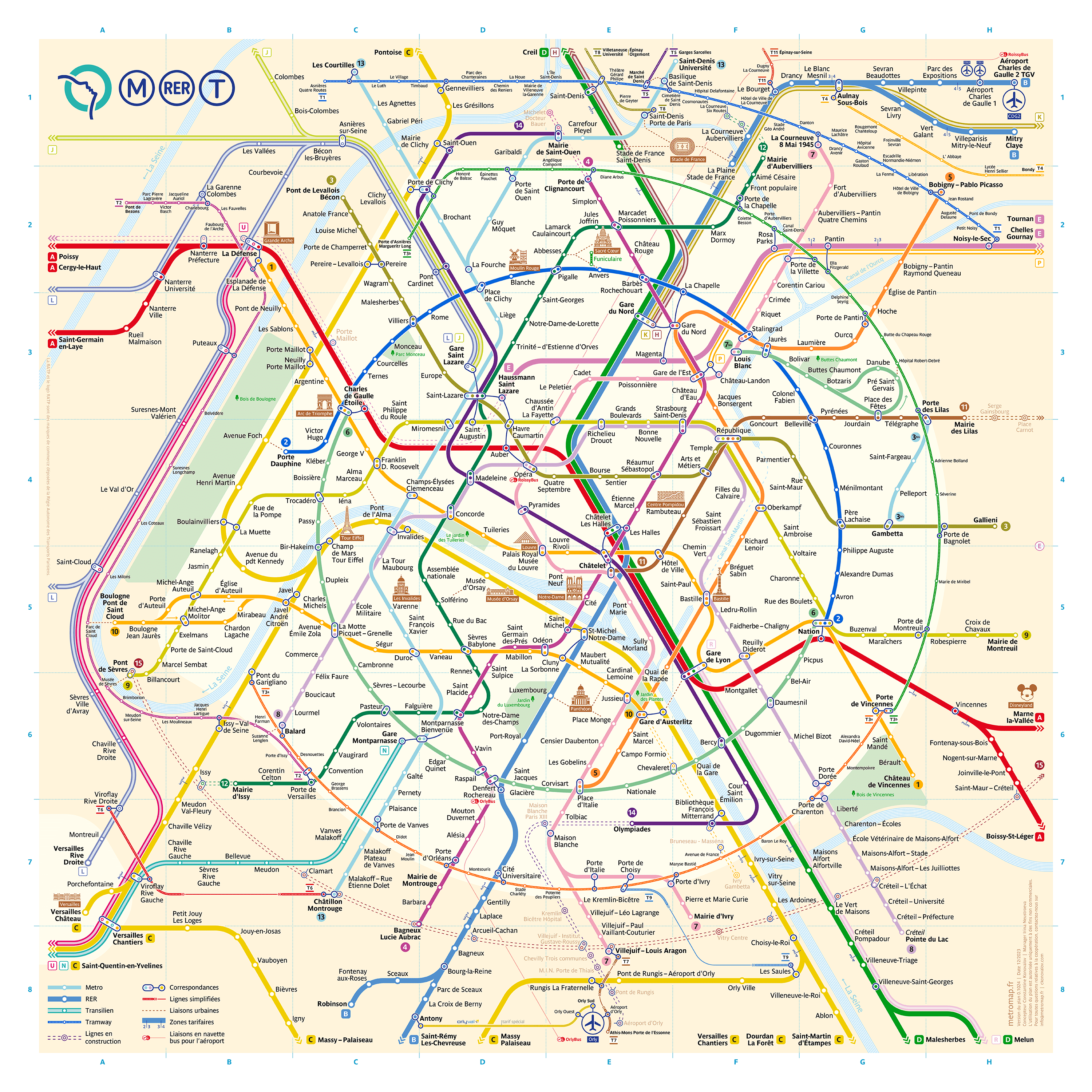
Konovalov’s Paris Métro Map
Designer Constantine Konovalov and his team spent more than two years creating this reimagined map of the Paris Métro system. Its design is based on circles: lines 2 and 6, which encircle the city core, are presented as a perfect circle, and the tramlines that follow the Péripherique form a circular arc as well. It’s quite well done; don’t miss the video on the site that timelapses through every iteration of the map’s design. Could someone navigate the RATP’s network with this map? I think so (though it’s been 19 years since I’ve been to Paris). See also Transit Maps’ analysis of the map.
Londonist Has the New Tube Map
Londonist has a “first peek” at the new Tube map, scheduled to be released next month. “Open it up, and you’ll see something straight away that is new—for the first time, TfL has added in the trams, even though they’ve been running since May 2000.”
New Orleans Is Sinking
“New Orleans and surrounding areas continue to sink at highly variable rates due to a combination of natural geologic and human-induced processes,” according to the findings of a new study that maps the rate at which New Orleans is sinking.
The maps were created using data from NASA’s Uninhabited Aerial Vehicle Synthetic Aperture Radar (UAVSAR), which uses a technique known as interferometric synthetic aperture radar (InSAR). InSAR compares radar images of Earth’s surface over time to map surface deformation with centimeter-scale precision. It measures total surface elevation changes from all sources—human and natural, deep seated and shallow. Its data must be carefully interpreted to disentangle these phenomena, which operate at different time and space scales. UAVSAR’s spatial resolution makes it ideal for measuring subsidence in New Orleans, where human-produced subsidence can be large and is often localized.
A History of the Tube Map
Speaking of London, Londonist has published an illustrated history of the Tube map, with examples both pre- and post-Beck.
Greater London A-Z Street Map
It shouldn’t surprise me that there’s a mobile version of the London A-Z Street Atlas. There are, in fact, several, the most recent of which is the Greater London A-Z Street Map, which covers some 3,743 km2 of territory and stores all its maps—the same maps you’d get in the paper edition—on the device. (Which makes it a fairly significant download: 603 MB on iOS, 382 MB on Android.) The iOS version costs £5 and is compatible with both the iPhone and iPad. The Android version is available on Google Play and costs about the same.
Herb Lester, Travel Guide Publisher

Gear Patrol interviews Ben Olins and Jane Smillie, the founders of travel guide publisher Herb Lester Associates. “[A]fter designing three unique maps in three major cities, they realized there was something to the idea of curating small guides (nothing too expensive, or too ordinary) accompanied by hand-drawn maps. As the company celebrates its sixth birthday this month, we caught up with the founders to chat about maps with personality, curating entire cities and the pitfalls of travel.” Amazon [NLS Maps]
Fuller Update

The Bristol Post reports on artist Gareth Wood (aka Fuller), whose iconic London Town—now acquired (as an archival print) by the British Library—was preceded by a similar map of Bristol. An exhibition of his work, called Get Lost, will run from 5 to 26 May at the Palm Tree Gallery, 291 Portobello Road, London, W10 5TD. [WMS]
Previously: Fuller: London Town.
Update: BBC News on institutions’ acquisitions of Fuller’s art.
20th-Century New York

Gothamist looks at A Map of the Wondrous Isle of Manhattan, a pictorial map from 1926 created by Charles Vernon Farrow. [NYPL]
Mosaic map murals graced the Times Square Information Center when it opened in 1957. Now the building is a police substation, and there are hopes and expectations that an upcoming renovation of the substation will preserve the murals. [NYPL]
Living in Gunter’s World
This short video, narrated by former Vancouver mayor (and current B.C. MLA) Sam Sullivan, explains how measurements initially set out by a 17th-century surveyor—in particular, Gunter’s chain—have an impact on the streets and lots of today’s British Columbia Lower Mainland.
Vancouver Archives Digitizing Old Maps

The City of Vancouver Archives: “Thanks to funding from the British Columbia History Digitization Program, we’ve recently completed a project to digitize over 2100 maps and plans and made them available online for you to use and re-use. We’ve tried to digitize these maps with enough resolution to support future types of re-use and processing, including optical character recognition and feature extraction.” A selection is available on Flickr. [WMS]
Edmonton Building Age Map
Online maps showing the age of buildings in cities seem to be a thing. In addition to the map of Paris we saw in February, there’s also this map for Edmonton, Alberta. (Wired put together a list of other cities’ building age maps in 2013.) [via]
The Tube Map of Lost London
The O-Train, Super Mario Brothers Style
Dave Delisle of Dave’s Geeky Ideas has been doing transit maps in the style of Super Mario Brothers 3; the latest to receive the SMB3 treatment is Ottawa (a city I’m familiar with, since it’s only an hour away). Posters are also available for sale (in non-animated versions, obviously).