
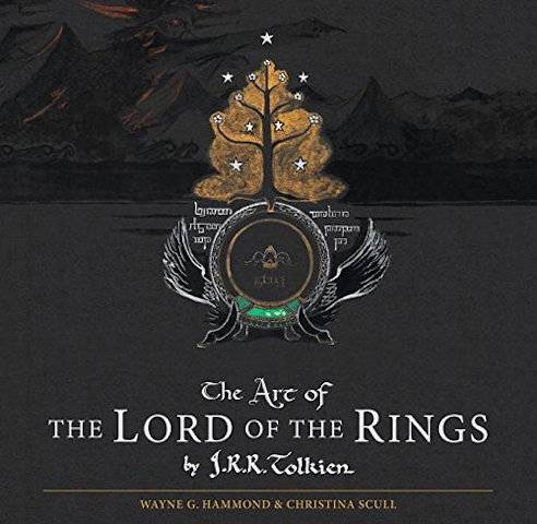
 When J. R. R. Tolkien was writing The Lord of the Rings, the map was not an afterthought. (For one thing, with characters travelling many miles over many months, separately and together, distances and dates had to add up.) Tolkien didn’t just draft; he drew—maps, sketches, drawings, whatever he needed to help him visualize the world he was inventing. About 180 of those maps and drawings are now collected in a new book out today: The Art of The Lord of the Rings, edited by Wayne G. Hammond and Christina Scull (who previously authored The Lord of the Rings: A Reader’s Companion). Wired has some sample images. (From what I can tell, the British edition is slipcased.) [Boing Boing/MetaFilter]
Author: Jonathan Crowe
Jonathan Crowe blogs about maps at The Map Room. His essays and reviews have been published by AE, Calafia, The New York Review of Science Fiction, the Ottawa Citizen, Strange Horizons and Tor.com. He lives in Shawville, Quebec.
Atlas of Cursed Places
 The first thing to keep in mind about Olivier Le Carrer’s Atlas of Cursed Places (Black Dog & Leventhal, October 2015) is that it’s not an atlas. Rather, it’s a collection of brief essays about a series of unique places around the world. In that I suspect it’s much like Judith Schalansky’s Atlas of Remote Islands or Aude de Tocqueville’s Atlas of Lost Cities (English translation forthcoming next year). All of these books shared a publisher in France; all of them appear to have been conceived under the influence of Calvino.
The Atlas of Cursed Places’s essays are about places in the world that are, for one reason or another, particularly horrible, by dint of their history or geography. There are navigational hazards and environmental disasters, and sites of old horrors that were entirely human-made. Ghost towns, war zones, slums and mausoleums. Animal infestations. Each are engrossing, but the essays barely get started on their subjects: turn the page expecting more and you find yourself already on the next one. Each essay is an act of cruelty (very meta given the subject matter), whetting readers’ appetites but denying us the feast.
In the end this is an exercise in curation: the choices are fascinating, but the essays are affective rather than substantive. In that sense this book is an even lighter read than Alastair Bonnet’s Unruly Places (which seems to have much less Calvino in its book DNA).
(While not an atlas proper, this book does have a lot of maps illustrating each essay. But their effect is disorienting: each cursed place is indicated by a star on an old and out-of-date map, usually a plate from a century-old atlas.)
I received an electronic review copy of this book from the publisher via NetGalley.
A Fantasy Map Roundup
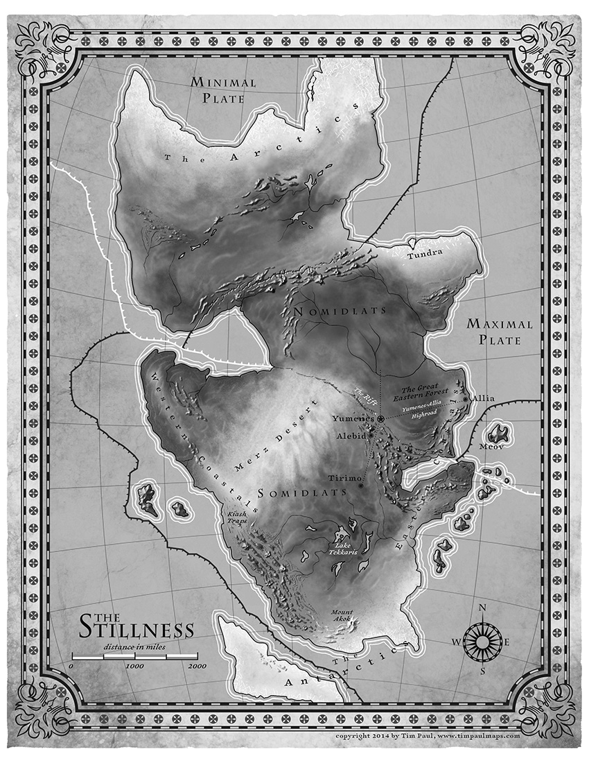 N. K. Jemisin talks about the map that accompanies her new fantasy novel, The Fifth Season. Uncharacteristically for a fantasy map, but appropriately for the novel, it indicates tectonic plate boundaries. Also uncharacteristic is its use of shaded relief to indicate mountains. The map was executed by Tim Paul, whose portfolio is here.
Tor.com is giving away 10 copies of a fold-out poster map that accompanies the boxed set of Brandon Sanderson’s Mistborn trilogy. (Entry deadline is October 9 at noon EDT.)
Jake Hayes is collecting maps from children’s fiction on Pinterest.
At The Funambulist last January, Léopold Lambert discussed the use of cartography in François Schuiten and Benoit Peeters’s 2004 graphic novel The Invisible Frontier (Vol. 1, Vol. 2).
As Fabrice Leroy exposes in “The Representation of Politics and the Politics of Representation in Schuiten and Peeters’s La Frontière Invisible,” (History and Politics in French-Language Comics, Jackson: The University of Mississippi Press, 2008, 117-136), two cartographic paradigms oppose each other throughout Schuiten and Peeters’ novel. The first one is carried by an old man, Monsieur Paul, who is committed to make maps that reflects on the historic conditions of a place, both at an individual empirical level and at a collective (inter)national one. This interpretation of the map is particularly illustrated in the first part of the story with the delicate care of each body interacting empirically with the model/terrain. The second one is also embodied by a character, Ismail Djunov, who undertook to automatize the process of map-making through monumental machines aiming at an objective cartography.
Something else for me to track down. The Invisible Frontier seems to be out of print.
New Edition of Transit Maps of the World
 A revised and expanded edition of Mark Ovenden‘s Transit Maps of the World is coming out in early November, presumably because the transit systems, and the maps thereof, have also been revised and expanded since the first edition was published in 2007. (My review of the first edition is here.) It’s being published by Penguin in the U.S. and Particular Books (a Penguin imprint) in the U.K. [Amazon]
Mercator Puzzle

The Mercator Puzzle is an excellent way to visualize the distortions inherent in the Mercator projection, which conserves angles (useful for navigation) by exaggerating size at the poles (problematic in virtually every other use). Click and drag the countries in this in-browser app to see just how dramatically larger or smaller they become as you move them closer to and further away from the poles. [Boing Boing]
Previously: Review: Rhumb Lines and Map Wars; Reversing the Mercator Effect.
Linear Lake Michigan

Cartographer Daniel Huffman, whose work I posted about a few times on The Map Room, has created a map of Lake Michigan in which the lake’s shoreline has been unfurled into a straight line. “I made this map because I wanted to show space referenced against a natural feature, rather than figuring locations based on the cardinal directions of north/south/etc.,” he says. “I think it’s a very human perspective, grounded in how we relate to the lake, rather than how it looks from space.” (With a 1:6 width/height ratio, it’s also insanely long, rather like a vertical Tabula Peutingeriana, and as such hard to display an excerpt of: you have to sacrifice detail or a sense of the whole. Which is to say: go and see the whole thing.) Via Kottke.
More Maps of Ceres

New maps of Ceres were released today at the European Planetary Science Conference in Nantes, France. One is a colour-coded topopgraphical map that resembles a map we saw earlier but adds newly approved names for topographical features. Another, the false-colour map seen above, combines imagery through infrared, red and blue filters and highlights compositional differences on Ceres’ surface (different materials reflect light at different frequencies).
Eleusinian Mysteries
Another fantasy story featuring maps, Charlotte Ashley’s “Eleusinian Mysteries,” appears in this month’s issue of Luna Station Quarterly. In it, a Javanese-Dutch mapmaker named Maghfira is punished for making maps of the moon that include a seemingly fanciful feature: a city named Eleusis. Naturally—this is an sf/fantasy story, after all—Eleusis turns out to be not so fanciful, and Maghfira gets herself into further trouble in its pursuit. The story says a little about maps and forbidden knowledge, rather more about about alienation and the urge to strike out into the unknown.
A Geographically Accurate Tube Map

There is no transit map more iconic than the London Underground’s Tube map. First created by Harry Beck in the 1930s, the design has inspired countless other transit network maps that are schematic diagrams rather than geographically accurate maps. But Transport for London, which operates the Underground, also has a geographically accurate map of the network: it was strictly for internal use, but a freedom of information request has now brought it to light. It’s available here (PDF). The response has been so good that TfL now says it’ll be added to their website. CityMetric, Mapping London.
Real World vs. Fantasy Maps
In my study of fantasy maps, one thing I’m particularly interested in is the difference between fantasy maps and their real-world counterparts. Those differences can be substantial; at some point I hope to go into a bit more depth about them. Meanwhile, James Hinton’s guest post at The Worldbuilding School tries to address this subject by comparing a single real-world city map (London, 1653) with a non-canonical map of Osgiliath from a role-playing game. His point turns out to be that fantasy settings should make sense (Osgiliath, according to the map, doesn’t): it’s a question of geography rather than cartography. The territory rather than the map. But if you begin building your fantasy world by drawing the map … [MetaFilter]
Atlas of Stereotypes
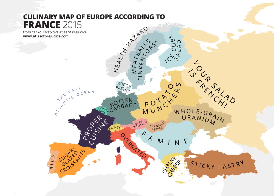
Back when I was doing The Map Room, I followed along as Yanko Tsvetkov started producing map after map of European stereotypes. The project really took off. He’s kept at it since, while I wasn’t looking quite as closely; he’s also collected them into two self-published volumes called the Atlas of Prejudice, which appear to have sold rather well in several different languages. As of July, an all-in-one edition, Atlas of Prejudice: The Complete Stereotype Map Collection, containing all the maps from the previous volumes plus 25 more, is now available.
Previously: Yanko Tsvetkov’s Beloved Europe; Mapping European Stereotypes; Stereotype Maps of the World, Unite!
Mind the Map
 A new book of map art is due out from Gestalten later this month. Mind the Map, edited by Antonis Antoniou, Robert Klanten and Sven Ehmann, seems very much in the same vein as their previous effort, A Map of the World. “Mind the Map is a showcase that reflects the broad range of work now being created by a new generation of mapmakers from around the world including classically legible maps, artistic experiments, editorial illustrations, city views, vacation guides, and global overviews.” The Guardian has some samples, as does the publisher’s catalog page.
Previously: The World According to Illustrators and Storytellers.
Fictional Maps International Conference
The Fictional Maps International Conference, an academic conference on the use of maps in fiction, will take place from January 21 to 23, 2016 at the University of Silesia’s Scientific Information Centre and Academic Library in Katowice, Poland. Stefan Ekman, the author of Here Be Dragons: Exploring Fantasy Maps and Settings (my review), is the keynote speaker. Deadline for submitting abstracts is October 30.
If you’ve been following along, you will instantly understand that this is very much relevant to my interests, and though it’s been an awfully long time since I’ve been in academic mode, I might have to figure out a way to go to this.
Plotted: A Literary Atlas
 Coming in October from Zest Books: Andrew DeGraff’s Plotted: A Literary Atlas, a collection of the artist’s maps of fictional worlds. The Huffington Post has an interview with the author and sample pages from the book, from which we can get a sense both of DeGraff’s distinct and idiosyncratic artwork and the books he chose to make maps for. They’re not necessarily books you’d expect maps for (e.g., A Christmas Carol). These are maps of the stories—not, as we see in fantasy maps, of the stories’ setting—which means a completely different perspective that takes into account both time and distance travelled.
Bellerby’s Hand-Painted Globes

Bellerby & Co. produces gorgeous hand-made, hand-painted globes. Peter Bellerby started the company six years ago—he wanted to make a globe for his father for his birthday, but got a bit carried away. Very much a luxury product: the least expensive item I could find in their catalogue was £999, and the higher-end and custom globes climb well into five figures. Not, in other words, comparable to Replogle’s product line.
Interesting behind-the-scenes photos at their Instagram account; see also their YouTube channel. Via Kottke.