
The late Bert Johnson’s collection of map ties—some 50 of them—has been donated to the Osher Map Library. See their Facebook post and Matthew Edney’s tweet for photos. Bert died in 2019; he was a stalwart of the Washington Map Society and friend of this blog, and apparently quite the snappy dresser.
Google Street View at 15
Google is marking the 15th anniversary of Street View. In a blog post, they preview their next camera, which weighs less than 15 pounds and doesn’t require complex equipment or a specialized car mount. They’re also making their historical Street View imagery (historical in the sense of not current: it only goes back 15 years at most) available via the Google Maps Android and iOS apps. More: 9to5Google, TechCrunch.
Mapping the Height of Earth’s Forests

NASA Earth Observatory’s map of Earth’s forest canopy height is based on estimates from a deep-learning model applied to Sentinel-2 optical data.
According to a research team led by Nico Lang of the EcoVision Lab at ETH Zürich, only 5 percent of the Earth’s land area in 2020 was covered with trees standing taller than 30 meters.
Lang, together with colleagues Konrad Schindler and Jan Wegner, produced the map by merging lidar data from NASA’s Global Ecosystem Dynamics Investigation (GEDI) mission with optical imagery from the European Space Agency’s Sentinel-2 satellites. GEDI’s lidar profiles give detailed canopy heights, but the profiles cover limited areas; Sentinel-2 optical data has abundant coverage, but it is not designed to measure canopy height. The researchers used the GEDI data to train a deep-learning model capable of estimating canopy heights from Sentinel-2 images anywhere on Earth.
Previously: New Map of Global Forest Heights.
Australian Federal Election Results
 Leading up to last Saturday’s federal election in Australia, ABC News Australia had a page explaining the usual problem with geographic electoral maps when sparsely populated rural districts are enormous and lots of voters are concentrated in the cities. Calling the page “The Australian electoral map has been lying to you” might have been torquing things a bit, though. Then again, via Maps Mania, live election results maps from The Australian and The Guardian both use straight geographic maps, so maybe not.
Bartosz Ciechanowski Explains GPS
Bartosz Ciechanowski writes long, detailed explanatory articles about physics, math and engineering that are full of interactive, animated diagrams. His article on GPS, posted last January, digs down into all its fundamentals, from the principles of trilateration to the orbital mechanics of GPS satellites to exactly what a GPS signal consists of. “It’s fascinating how much complexity and ingenuity is hidden behind the simple act of observing one’s location in a mapping app on a smartphone. What I find particularly remarkable is how many different technological advancements were needed for GPS to work.”
All Online Maps Don’t Suck?
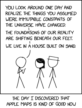 The notion expressed in Monday’s xkcd, particularly in the alt-text—
OpenStreetMap was always pretty good but is also now really good? And Apple Maps’s new zoomed-in design in certain cities like NYC and London is just gorgeous. It’s cool how there are all these good maps now!
—is unexpectedly more on point than not.
In 2013 I wrote a screed saying that all online maps sucked: that no one map platform had a monopoly on errors. At the time Exhibit A for the suckiness of online maps was Apple Maps; since then, and particularly since 2018, Apple has been putting in the work. Not that they’re done, but still: the product is fundamentally better now than it was then. And it’s not like the other platforms have been idle in the meantime. No one platform is going to achieve Cartography’s ideal of the universal and accurate Map—that’s inherently unachievable—but better? I’ll take better.
Google I/O: Immersive View and Other Updates to Google Maps
Three updates to Google Maps were announced at Google I/O today. The big one is an immersive view mode that creates a digital model of a city from aerial imagery and Street View: it’s coming later this year to London, Los Angeles, New York, San Francisco and Tokyo, with more cities coming later. It’s not just about 3D models of buildings—Apple’s got those—but also interiors, as Google CEO Sundar Pichai demonstrated in the keynote.
Also announced: an expansion of eco-friendly routing to Europe and making Live View available to third-party apps. More coverage: Engadget, TechCrunch, The Verge.
One Racial Dot Map Closes, Several New Ones Appear
Maps Mania reported last month that the University of Virginia’s Racial Dot Map has been taken offline. The proximate causes: the 2020 census, which rendered the map obsolete (it was based on 2010) data; the increased complexity of the 2020 census’s racial data (more people IDing as multiracial or other); and insufficient resources to bring the map up to date given that complexity. But Maps Mania points to a number of new racial dot maps, such as CNN’s and Ben Schmidt’s All of US, which operate despite the caveats identified by UVa; plus see the following previous posts: Census Mapper: An Interactive Map of U.S. Population Changes; Mapping Racial Population Shifts in the United States.
Topsy-Turvy: The London Underground in the Style of the New York Subway Map

Plenty of cities’ subway maps have been reimagined in the style of the London Underground map. Cameron Booth, for example, has redone New York’s subway map in that style. But a map posted by a graphic designer named Sean to Reddit does the exact opposite: it reimagines the London Underground map in the style of New York’s subway map. Bringing the design language of Michael Hertz to Harry Beck’s sovereign territory is probably blasphemous in some quarters, but as a pastiche of the New York style? Cameron says: “Sean has absolutely nailed the New York Subway map style, and perhaps even improved upon it in places—I note with pleasure that all of his station labels are set horizontally, instead of the many varied angles used on the official NYC map.” His bottom line? “One of the best style mash-ups I’ve seen: technically excellent, well-researched and actually really informative. Wonderful!”
It’s available as a print on Etsy, because of course it is.
Mercator: Extreme
To follow-up on xkcd’s Madagascator cartoon (previously), I missed the fact that clicking on the cartoon at the xkcd website actually did something, but Keir caught it: it links to Drew Roos’s Mercator: Extreme, an online tool that allows you to have some fun with the Mercator projection’s excessive polar distortion by making any point on the planet the North Pole and which clearly served as Randall’s inspiration.
Pictorial St. Louis

On the Library of Congress’s map blog, World’s Revealed, Julie Stoner takes a look at a rather unusual example of a bird’s-eye (or panoramic) city map. “The Geography and Map Division has over 1,700 of these beautiful panoramic maps in the collection, but one item stands out above all the others as one of the crowning achievements of the art, Camille N. Dry’s 1875 atlas, Pictorial St. Louis; The Great Metropolis of the Mississippi Valley. A visually stunning atlas, instead of only one sheet, it was produced on 110 plates, which if trimmed and assembled creates a panorama of the city measuring about 9 by 24 feet.”
xkcd’s Madagascator Projection
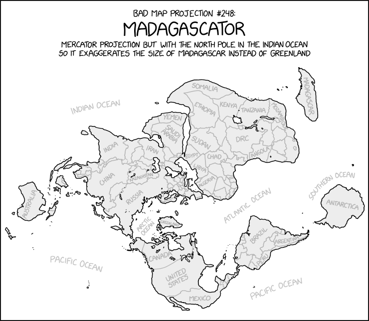
Uncharacteristically for xkcd’s Bad Map Projection series, the Madagascator is actually totally legitimate as a projection. Not that it’s any less mischievous, mind.
Update, 3 May: Turns out there was more to this xkcd cartoon. See Mercator: Extreme.
Updates to Maps of Historical Earthquakes, Tsunami and Volcanic Eruptions

Every two years or so, NOAA’s National Centers for Environmental Information updates poster maps based on its Global Historical Tsunami, Significant Earthquake and Significant Volcanic Eruption databases; the 2022 editions are now available. The posters, made in collaboration with the International Tsunami Information Center, are distributed to emergency response personnel; they provide a historical overview of where earthquakes or eruptions took place, or tsunami originated, going back literally millenia. The maps can be downloaded in PDF format: Significant Earthquakes 2150 B.C. to A.D. 2022, Tsunami Sources 1610 B.C. to A.D. 2022, and Significant Volcanic Eruptions 4360 B.C. to A.D. 2022.
The Gough Map and Its Ghostly Predecessor

An update on the Gough Map Project from Bill Shannon. “The Gough Map Project has reached that ‘interesting’ stage where we are moving from either sitting on the fence and making no decisions, or making lots, but then rejecting them all. It is now time to reach some firm conclusions, and start writing.”
Among other things, the Gough Map appears to be a copy of, and updated from, an earlier (“ghost”) map:
And so, we now have still more questions as we turn over the possible scenarios. If the copying was done in the early years of Henry IV, when was the Predecessor made? And where? And why? And why was our copy made—and where? And, what about that shipwreck? And, especially, what about those red lines previously interpreted as “roads”: it seems quite clear that these were not on the Predecessor, which means it never was a road map. Indeed, as we have progressed, we have realised those red lines are, at best, routes. […] But one thing we feel sure of: Mr Gough’s map was never a high-quality, show-piece display object; it was a back-room, practical, work-a-day thing.
Previously: Understanding the Gough Map.
A Striped Circle Map of the French Presidential Election Results

Julien Gaffuri’s map of the second-round results of the French presidential election is, as you can see, extraordinarily busy—and, by the way, extremely processor-intensive: it will slow down your machine—because it’s at the commune level and each circle is scaled to population. (News flash: Paris has lots of people in it.) And those circles are striped circles: the proportion of the votes is indicated by the area taken up by a given colour. The map of the first round results shows more stripes (because more candidates) but is by department, so it’s a little easier both to read and to see how the striped circle format works. It’s an interesting alternative to a choropleth map, and a bit less ambiguous.