
Another fantasy story featuring maps, Charlotte Ashley’s “Eleusinian Mysteries,” appears in this month’s issue of Luna Station Quarterly. In it, a Javanese-Dutch mapmaker named Maghfira is punished for making maps of the moon that include a seemingly fanciful feature: a city named Eleusis. Naturally—this is an sf/fantasy story, after all—Eleusis turns out to be not so fanciful, and Maghfira gets herself into further trouble in its pursuit. The story says a little about maps and forbidden knowledge, rather more about about alienation and the urge to strike out into the unknown.
Author: Jonathan Crowe
Jonathan Crowe blogs about maps at The Map Room. His essays and reviews have been published by AE, Calafia, The New York Review of Science Fiction, the Ottawa Citizen, Strange Horizons and Tor.com. He lives in Shawville, Quebec.
A Geographically Accurate Tube Map

There is no transit map more iconic than the London Underground’s Tube map. First created by Harry Beck in the 1930s, the design has inspired countless other transit network maps that are schematic diagrams rather than geographically accurate maps. But Transport for London, which operates the Underground, also has a geographically accurate map of the network: it was strictly for internal use, but a freedom of information request has now brought it to light. It’s available here (PDF). The response has been so good that TfL now says it’ll be added to their website. CityMetric, Mapping London.
Real World vs. Fantasy Maps
In my study of fantasy maps, one thing I’m particularly interested in is the difference between fantasy maps and their real-world counterparts. Those differences can be substantial; at some point I hope to go into a bit more depth about them. Meanwhile, James Hinton’s guest post at The Worldbuilding School tries to address this subject by comparing a single real-world city map (London, 1653) with a non-canonical map of Osgiliath from a role-playing game. His point turns out to be that fantasy settings should make sense (Osgiliath, according to the map, doesn’t): it’s a question of geography rather than cartography. The territory rather than the map. But if you begin building your fantasy world by drawing the map … [MetaFilter]
Atlas of Stereotypes
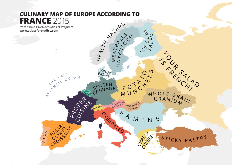
Back when I was doing The Map Room, I followed along as Yanko Tsvetkov started producing map after map of European stereotypes. The project really took off. He’s kept at it since, while I wasn’t looking quite as closely; he’s also collected them into two self-published volumes called the Atlas of Prejudice, which appear to have sold rather well in several different languages. As of July, an all-in-one edition, Atlas of Prejudice: The Complete Stereotype Map Collection, containing all the maps from the previous volumes plus 25 more, is now available.
Previously: Yanko Tsvetkov’s Beloved Europe; Mapping European Stereotypes; Stereotype Maps of the World, Unite!
Mind the Map
 A new book of map art is due out from Gestalten later this month. Mind the Map, edited by Antonis Antoniou, Robert Klanten and Sven Ehmann, seems very much in the same vein as their previous effort, A Map of the World. “Mind the Map is a showcase that reflects the broad range of work now being created by a new generation of mapmakers from around the world including classically legible maps, artistic experiments, editorial illustrations, city views, vacation guides, and global overviews.” The Guardian has some samples, as does the publisher’s catalog page.
Previously: The World According to Illustrators and Storytellers.
Fictional Maps International Conference
The Fictional Maps International Conference, an academic conference on the use of maps in fiction, will take place from January 21 to 23, 2016 at the University of Silesia’s Scientific Information Centre and Academic Library in Katowice, Poland. Stefan Ekman, the author of Here Be Dragons: Exploring Fantasy Maps and Settings (my review), is the keynote speaker. Deadline for submitting abstracts is October 30.
If you’ve been following along, you will instantly understand that this is very much relevant to my interests, and though it’s been an awfully long time since I’ve been in academic mode, I might have to figure out a way to go to this.
Plotted: A Literary Atlas
 Coming in October from Zest Books: Andrew DeGraff’s Plotted: A Literary Atlas, a collection of the artist’s maps of fictional worlds. The Huffington Post has an interview with the author and sample pages from the book, from which we can get a sense both of DeGraff’s distinct and idiosyncratic artwork and the books he chose to make maps for. They’re not necessarily books you’d expect maps for (e.g., A Christmas Carol). These are maps of the stories—not, as we see in fantasy maps, of the stories’ setting—which means a completely different perspective that takes into account both time and distance travelled.
Bellerby’s Hand-Painted Globes

Bellerby & Co. produces gorgeous hand-made, hand-painted globes. Peter Bellerby started the company six years ago—he wanted to make a globe for his father for his birthday, but got a bit carried away. Very much a luxury product: the least expensive item I could find in their catalogue was £999, and the higher-end and custom globes climb well into five figures. Not, in other words, comparable to Replogle’s product line.
Interesting behind-the-scenes photos at their Instagram account; see also their YouTube channel. Via Kottke.
And in Google Maps News …
Google’s Map Maker is in the process of reopening, with six countries reopening on August 10 and another 45 countries last Monday. Map Maker, Google’s tool allowing users to make changes to Google Maps, was suspended last May after some embarrassing edits came to light. Regional leads are now in place to review user edits before they go live on the map.
If mapcodes and other geographical shortcodes aren’t Googly enough for you, take a look at Open Location Codes, a Google-developed, open-sourced project. Generated algorithmically rather than with data tables. Announced for developers last April, they can now be used in Google Maps searches.
New Maps of Ceres and Pluto

As I predicted, a new global map of Pluto has been released that incorporates the imagery that has been downlinked so far from the New Horizons flyby: with gridlines, without gridlines. If nothing else, the equatorial projection demonstrates how much of Pluto’s surface was not seen during the very brief encounter. From what I understand, imagery downlinks will resume in September and carry on for another year, so this map will almost certainly see many more updates.
Meanwhile, Ceres also has some new maps.
Three Books on WWII Maps
- Great Escapes: The Story of MI9’s Second World War Escape and Evasion Maps by Barbara Bond (Times Books, October 2015): history of the escape maps produced for prisoners of war.
- Mapping the Second World War by Peter Chasseaud (Collins, October 2015): a collection of historical maps; follow-up to Chasseaud’s 2013 book Mapping the First World War.
- Mapping the Second World War: The Key Battles of the European Theatre from Above by Michael Swift and Michael Sharpe (Conway Maritime Press, November 2014).
Previously: Two Books on WWI Maps.
History of Cartography Project’s Sixth Volume Now Out

The sixth volume of the massive History of Cartography Project, Cartography in the Twentieth Century, is now available. Edited by Mark Monmonier, it takes two physical volumes and nearly two thousand pages to cover mapmaking in the twentieth century—and lists for an eye-popping $500 (U.S.), though it’s a bit cheaper on Amazon.
Volumes one through three are available for free download. Volumes four and five, covering the European Enlightenment and the nineteenth century, respectively, are still in development.
Previously: History of Cartography Project Co-Founder Dies.
Mapcodes
The New Yorker‘s Elements blog has a piece about mapcodes. These are short alphanumeric codes assigned to every location on the planet, with short codes reserved for areas of high population density. It’s meant to be a substitute for latitude and longitude, and aimed at parts of the world where there are no formal addresses (which makes directions somewhat interesting): give someone a mapcode, and you’re giving them a very precise location.
The Peace Tower in Ottawa, for example, has an Ontario mapcode of 09W.YK (mapcodes exist within country and state/provincial contexts).
The main problem, as I see it, is that while the Mapcode Foundation is trying to make mapcodes a standard, it still relies on data tables to produce the code, which is to say that there’s some computational overhead. Whereas something like Universal Transverse Mercator coordinates can be derived from topo maps (which have UTM grids on them).
The Best Map of Pluto Ever (Until Some Time Later This Month)

The New Horizons spacecraft’s rendezvous with Pluto is next week, folks, but we’re already getting better views of our favourite dwarf planet than we’ve ever had before. NASA has assembled images taken between June 27 and July 3 into the above map, which despite its relatively low resolution shows some intriguing surface features: the so-called “whale” and “donut.” (Of course, low resolution is relative: this is already much better than the Hubble-based maps of Pluto released in 2005 and 2010.)
Robert Lazzaretti, Fantasy Mapmaker

Lou Anders interviews fantasy mapmaker Robert Lazzaretti, who drew the maps for Anders’s Thrones and Bones series (Frostborn, Nightborn). I can never get enough information about the process of making fantasy maps.
Previously: Mapping An Ember in the Ashes; How to Make a Fantasy Map.