
The Onion: MTA Admits to Fabricating Large Parts of Subway Map. “‘Frankly, no one I know has ever ridden farther than the Carroll Street Station in Brooklyn. We’re not really sure what’s out there, but we figured we’d better put something on the map. Now we see the error in our ways. It was a mistake to trick New Yorkers into believing the G train exists—it does not.’” (Responses on social media are invariably some variant of I knew it.)
Tag: funny
The Onion Doesn’t Miss
The Onion: “An alarming new educational survey has found more than 70% of Americans lack the basic geographic literacy to locate the country, region, or continent they are currently being deported to.”
How xkcd Does Maps
Randall Munroe, author of the xkcd web comic, posts a surprising amount of map-related content, which I invariably end up linking to here. With some exceptions, they fall into one of two categories, each of which has a recent example.
The first category is a hand-drawn infographic map showing, in earnest, some interesting or surprising information. See, for example, this map showing the most observed animal or plant in each U.S. state:

Other maps of this ilk include drainage basins, lesser-known towns sharing a famous place name, least informative Google Trends maps, and maps of the 2016, 2018 (challengers) and 2020 elections.
The second category is where Randall chooses the path of violence, with maps clearly designed by Black Hat Guy to hurt our brains. These include a series of maps that mangle U.S. state borders (1, 2, 3). But the most insidious are his Bad Maps Projections series, the most recent of which projects continents onto their own globes:

Thing is, this one isn’t as brain-curdling, because similar globes—globes that depict a portion of the world on an entire sphere—exist in the real world.
The Map Men Visit the Ordnance Survey, and Also Wrote a Book

Map Men Jay Foreman and Mark Cooper-Jones visit the Ordnance Survey in a (sponsored) set of two (vertically aligned short) videos: part one, part two. Complete with map-folding mishaps, gratuitous hi-viz vest wearing, and a Google Maps dig.
Meanwhile, they’ve also gone and written a book: This Way Up: When Maps Go Wrong (and Why It Matters) will be out from HarperCollins imprints in the fall of 2025: the U.K. edition will come out from Mudlark in October (£17) and the U.S. edition from Hanover Square Press in November ($30). Amazon (Canada, UK), Bookshop.
A Globe Safety Tip from xkcd

In Wednesday’s xkcd comic, Replogle has apparently been taken over by mad scientists. I’m having a hard time resisting the urge to explain the joke (I doubt many of my readers are physicists, but then I’m not one either). But in a weird Einsteinian way Randall is doing with globes and mass what Carroll, Borges and Eco did with maps and space: assume a 1:1 ratio between the map and the mapped.
Getting on the Name-Changing Bandwagon
Illinois governor J. B. Pritzker has decided to get in on the whole unilateral name-changing thing.
See also Barry Blitt’s cartoon in The New Yorker.
Previously: Naming the Gulf; Google Maps to Use ‘Gulf of America’–Others Not So Much; More Reactions to ‘Gulf of America’.
‘A 50/50 US/Australia Blend’ from xkcd

Morphing maps of the U.S. and Australia into one hot mess is more of a Star Trek transporter accident than a map projection, if we’re being nitpicky; what’s surprising is that the result is almost viable. Almost.
xkcd: ‘Exterior Kansas’

In the latest iteration of xkcd’s series of bad map projections, Randall puts Kansas—the putative centre of the contiguous 48 states—at the edge of the map.
Why Oh Why Does an Alphabetical Cartogram Have to Be a Thing?

More proof that Randall hates us and wants to hurt our eyes comes from last Wednesday’s xkcd, which does what I’m pretty sure no cartogram has ever done: size by alphabetical order.
The Map Men on Phantom Islands
There’s no shortage of books about phantom islands—islands on the map that later turn out never to have existed—but now the Map Men have done a video about them, using as a narrative hook the case of Sandy Island, and how it managed to stay on maps into the Google Maps era.
xkcd: ‘Every Eclipse Path Map’

Looks like we’re not quite done with eclipse maps, especially the whimsical sort, and it’s not at all invalid for xckd to have (what is probably going to be) the last word on the subject (at least for a while), with this fictional map showing the fictional path of a fictional eclipse over a fictional landscape, with rueful descriptions of fictional places where trying to see the fictional eclipse will come to a bad end for the fictional observers. (And you thought it was bad you got clouds.)
Worst Eclipse Map Ever Becomes the Funniest
This Mastodon post makes a bad map of this week’s eclipse into the funniest map of this week’s eclipse.
xkcd on Greenland’s Size
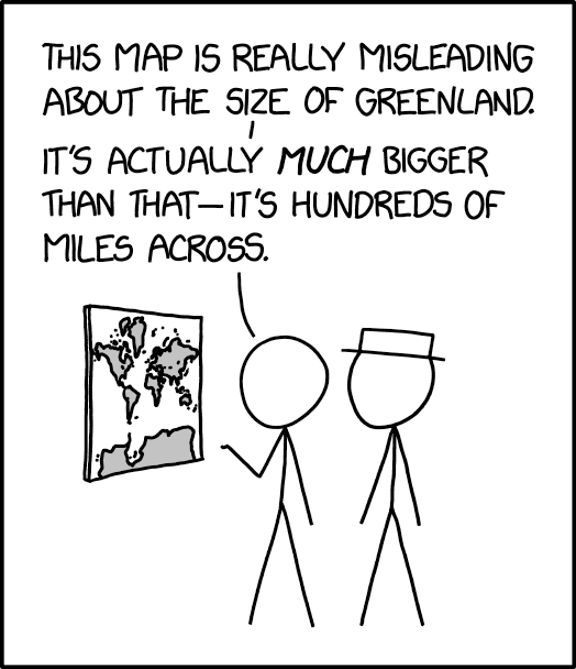
The 25 March 2024 xkcd honours Greenland’s place as a measure of cartographic distortion. It’s also, unexpectedly, a riff on the idea of the 1:1 scale map (cf. Borges), especially if you consult the comic’s alt text: “The Mercator projection drastically distorts the size of almost every area of land except a small ring around the North and South Poles.”
Previously: xkcd: The Greenland Special.
xkcd’s Geography Challenge
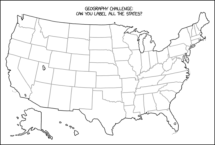
Stare at this map for a while until you figure out what Randall Munroe has done in last Friday’s xkcd. Then scream. (Kottke says: “This is evil.”) It’s not the first time that xkcd has committed mischief and violence on an outline map of the contiguous United States: see, for example this one, or this one. I worry it may not be the last.
Previously: xkcd’s United States Map; The Contiguous 41 States—Wait, What?
‘Where Comedy Meets Geography’
Geographical magazine has a profile of the Map Men—that is, Jay Foreman and Mark Cooper-Jones, who’ve been posting funny videos on YouTube that explain some cartographical or geographical silliness since 2016, on and off.
‘As little as ten years ago, maps were something that you just had to live with and everybody had an A-to-Z in the car,’ says Jay, who is the main comedic influence behind the channel, having already found success with a series on London’s architecture called Unfinished London. ‘But now that everyone has a sat nav, I think maps have become, for want of a better word, more geeky. You get people who didn’t realise that they were interested in maps or geography until they see an episode of Map Men and they’ll say: “Oh, yeah, maps are my guilty pleasure.” And I don’t think people would have necessarily talked like that about maps ten years ago, because they used to be something that we depended on. And now they have become something that we enjoy.’
(See previous posts.)