
A funny quirk of social media is that despite having more followers on Twitter than Facebook (4,100 vs. 2,400 at the moment), and even with Facebook algorithms that seem to reduce page views for any post with commercial intent (e.g. product links) so you can pay to boost it, The Map Room consistently gets twice as much traffic from Facebook as it does from Twitter. Go figure. (Google+ traffic is 10 percent Facebook’s; Tumblr’s is a rounding error.)
Author: Jonathan Crowe
Jonathan Crowe blogs about maps at The Map Room. His essays and reviews have been published by AE, Calafia, The New York Review of Science Fiction, the Ottawa Citizen, Strange Horizons and Tor.com. He lives in Shawville, Quebec.
A-Z Adventure Atlas Series
 London Hiker reviews the A-Z Adventure Atlas series of maps. “They contain 1:25,000 scale Ordnance Survey maps, but in a book format, like the A-Z street map books you’re probably used to. […] Many of the new A-Z style map books are extremely convenient and are fast becoming a favourite with me, depending on the circumstances.”
Map Auction News: Early American History

- The Courier-Journal of Louisville, Kentucky: “A rare 18th-century wall map depicting frontier Kentucky that was put up for auction Thursday in New York has sold for $37,500—more than twice its high estimated value.” (See the Library of Congress’s copy of the map above.) [WMS]
- “Two large maps and six sketches of military defenses hand drawn by French military engineers in 1781 and used during the American War of Independence, the last such documents in private hands, will be auctioned off at a chateau in France next month,” Bloomberg reports. “Salvaged in 2007, the maps—that only barely escaped becoming mouse food—show British defenses along the East Coast, including fortifications near New York. They are being sold by the eighth-generation descendants of Marshall de Rochambeau, the commander of the French expeditionary force sent by King Louis XVI to aid the American rebels.” [WMS]
More books have been added to the Map Books of 2016 page: have a look. Some are available right now; others you’ll have to preorder. As usual, buying via this website helps support The Map Room.
I thought about doing a similar page listing map colouring books for adults, but it seems redundant when you can just refer to the colouring books tag (or the coloring books tag, if you’re going to be insistently American).
What’s Going to Happen to the Boston Globe’s Marble Map of New England?
The problem with big maps—the Electric Map of Gettysburg, the B.C. Challenger Map—is that they’re exceedingly difficult to move when the time comes. Betsy Mason at All Over the Map reports that this is now the situation at the Boston Globe: since 1978 their headquarters has been the home of an 18-by-12-foot, four-ton marble map of New England that had originally been commissioned for the Federal Reserve Bank of Boston in 1953. But now the cash-strapped Globe is moving to smaller digs, and there isn’t room for the map. Boston’s a relative hotbed of map activity, so I’m hopeful it can find a home.
Maps of the Netherlands Antilles
 If you can read Dutch, there’s a new book about the old maps of the Netherlands Antilles: Wim Renkema’s Kaarten van de Nederlandse Antillen: Curaçao, Aruba, Bonaire, Saba, Sint Eustatius en Sint Maarten tot 1900 (Brill, May 2016). Includes an English summary if you can’t; I presume it’s heavily illustrated. More from the Daily Herald of St. Maarten. Buy at Amazon. [WMS]
Mapping the Decline of English Dialects

Using a mobile app launched last January (iPhone, Android), similar to the one used to study Swiss German dialect usage, Cambridge researchers have amassed a huge dataset of English language usage and are using it to map the decline in regional dialect words and pronunciations. [The Telegraph]
xkcd’s Map Age Guide
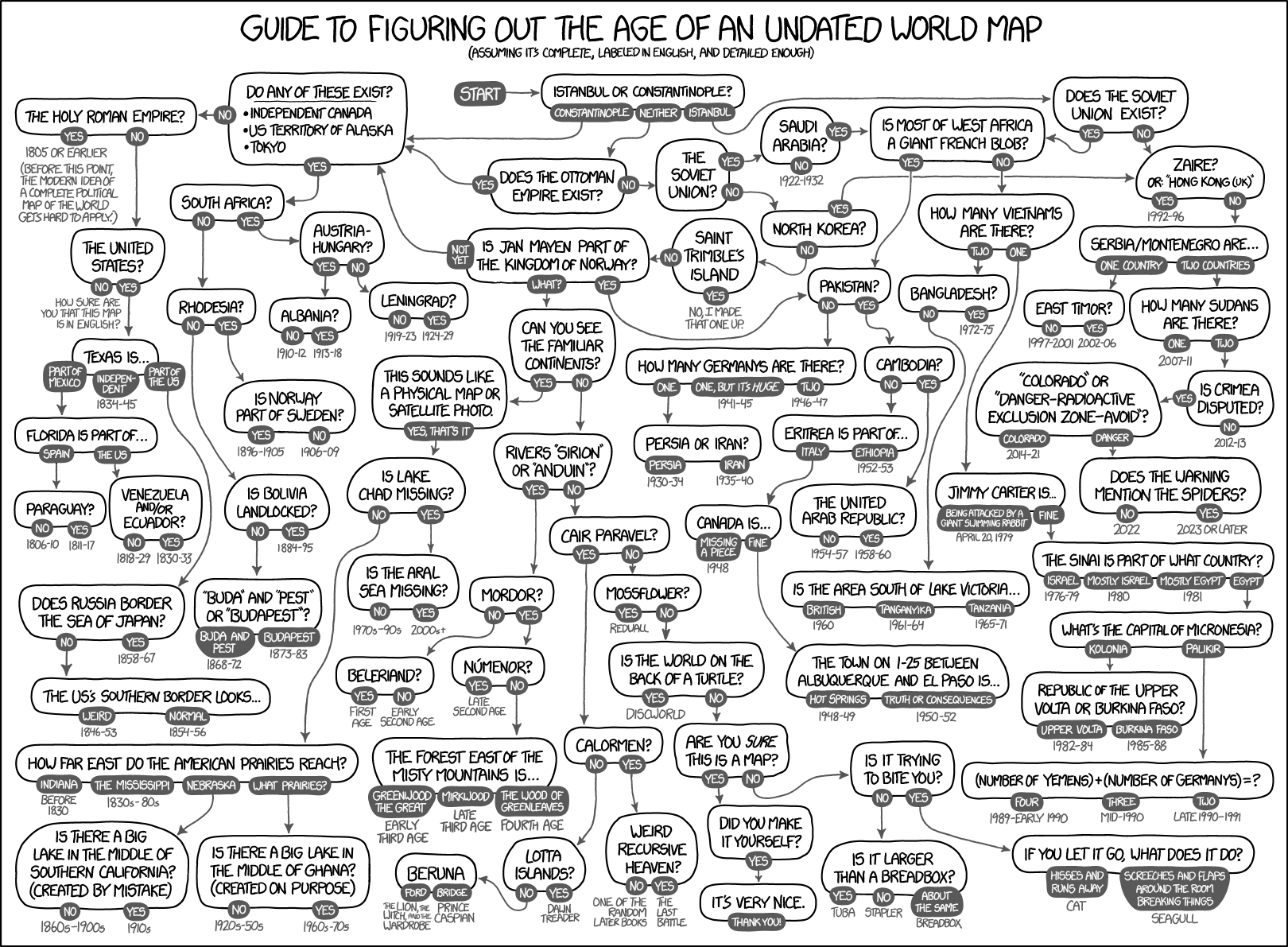
Today’s xkcd is a flowchart for figuring out the age of an undated world map. Look carefully.
‘I Have Been Paid to Do a Hobby’
On 12 May map dealer Jonathan Potter gave a talk for the Maps and Society lectures at the Warburg Institute. A précis of that talk, “A Map Dealer’s Reflections on the Last Forty-Five Years,” is now available online. [WMS]
Londonist Has the New Tube Map

Londonist has a “first peek” at the new Tube map, scheduled to be released next month. “Open it up, and you’ll see something straight away that is new—for the first time, TfL has added in the trams, even though they’ve been running since May 2000.”
A-Z Maps Colouring Book
 There are more map colouring books out there than I realized (I’m going to have to compile a list). For example, A-Z Maps’ Maps: A Colouring Book, which came out last October. From the publisher: “This adult colouring book includes a number of street maps from around Great Britain including London, Edinburgh, Cardiff and Manchester, together with some more unusual designs—contour lines around Ben Nevis, Scafell Pike and Snowdon and some fascinating map mandalas (intricate patterns created by repeating sections of mapping around a central point).” Buy at Amazon. [A-Z Maps]
Previously: Albion’s Glorious Ile: A 400-Year-Old Map Colouring Book; City Maps: An Adult Colouring Book.
Albion’s Glorious Ile: A 400-Year-Old Map Colouring Book
 What’s old is new again. Maps created by engraver William Hole to illustrate Michael Drayton’s 17th-century, 15,000-line poem Poly-Olbion are being reprinted—as an adult colouring book called Albion’s Glorious Ile, coming out next month from Unicorn Press (pre-order at Amazon).
As the Guardian article about the book points out, hand-colouring maps and illustrations was a common activity before full-colour printing was a thing, so the current mania for adult colouring books—Gretchen Peterson’s City Maps: A Coloring Book for Adults is The Map Room’s best-selling book this year by a large, large margin—can in some ways be seen as a reversion rather than a new thing.
The Guardian has a gallery of Hole’s maps (taken from the colouring book). The Poly-Olbion Project also has a page about Hole’s maps. [WMS]
Previously: City Maps: An Adult Colouring Book.
ICHC 2019
As I mentioned earlier this month, the 27th International Conference on the History of Cartography takes place on 9-14 July 2017 in Belo Horizonte, Brazil. If you want to look even further ahead, it’s just been announced that the 28th ICHC will be held in Amsterdam on 14-19 July 2019. ICHC page. [WMS]
CBS News on the Persistence of Traditional Map-Making
Here’s a CBS News story on the persistence of paper maps in the digital age. Featuring quotes from University of Wisconsin cartographer Daniel Huffman and Library of Congress map librarian John Hessler, it’s more about the persistence of non-smartphone (read: non-Google) maps rather than paper. [WMS]
Whither Here Maps?
Last August Nokia sold its Here map service to a consortium of German automakers for roughly half what it paid for it (when it was Navteq) in 2007. What has Here been up to since? This interview with a Here vice-president doesn’t really offer much in the way of specifics, and rather a lot about data and business partnerships rather than consumer product.