
 A map of Scarfolk has been announced. For those blissfully unaware, Scarfolk is Richard Littler’s fictional, satirical English town locked in a 1970s-era dystopia. Littler has been producing deeply creepy examples of graphic design—public information posters, mainly—purporting to emanate from Scarfolk authorities on his blog and in two books so far. This “road and leisure map for uninvited tourists,” which apparently comes with a postcard and visa, costs £12. As they say in Scarfolk: For more information please reread. [via]
Tag: fun
SMBC Takes the Mercator Projection into Its Own Hands

Saturday Morning Breakfast Cereal’s take on the Mercator projection is … not what you’d expect. The punch line is similar to Christopher Rowe’s short story, “Another Word for Map Is Faith”: if you can’t make the map conform to the territory, make the territory conform to the map. Since we’re dealing with the Mercator projection, this requires some … escalation.
xkcd: Reaction Maps
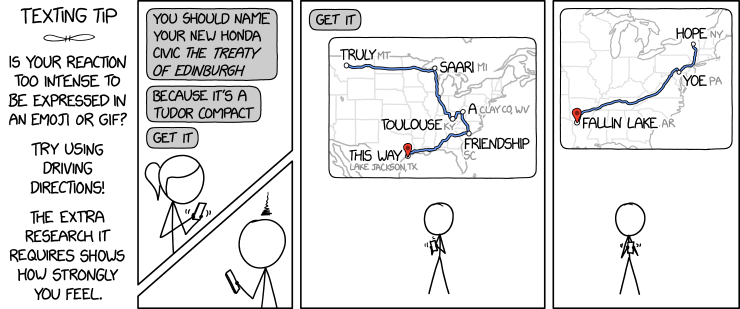
The latest xkcd comic suggests a fiendish way to express yourself: by creating phrases from driving direction waypoints.
An obvious upgrade would be to use one or more of the places from the Magnificently Rude Map of World Place Names (previously).
xkcd: All South Americas
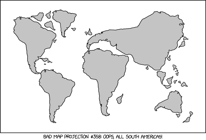
xkcd is back with another bad map projection: in this one, it’s all South Americas. The alt-text: “The projection does a good job preserving both distance and azimuth, at the cost of really exaggerating how many South Americas there are.”
Previously: xkcd’s Time Zone Map; xkcd’s Liquid Resize Map Projection; xkcd’s United States Map.
Poorly Drawn Lines Maps the Snark

Last month Poorly Drawn Lines, the web comic by Reza Farazmand, published “Welcome,” a comic that with its blank map of the ocean channels Lewis Carroll’s 1876 poen The Hunting of the Snark.
If you’re not familiar with that poem, here’s the key passage:
He had bought a large map representing the sea,
Without the least vestige of land:
And the crew were much pleased when they found it to be
A map they could all understand.“What’s the good of Mercator’s North Poles and Equators,
Tropics, Zones, and Meridian Lines?”
So the Bellman would cry and the crew would reply
“They are merely conventional signs!“Other maps are such shapes, with their islands and capes!
But we’ve got our brave Captain to thank:”
(So the crew would protest) “that he’s bought us the best—
A perfect and absolute blank!”
And here’s the accompanying map:

(More at Strange Maps. Source for the above image.)
SMBC’s Alternatives to a Flat Earth

It’s not like xkcd has a monopoly on comics about maps. Last week, Zach Weinersmith’s Saturday Morning Breakfast Cereal web comic posted a comic about alternative non-spherical Earth theories: everything from a hollow Earth to, well, stranger variations—including a slightly lumpy oblate spheroid Earth, which I frankly find hard to believe in.
xkcd on Coordinate Precision
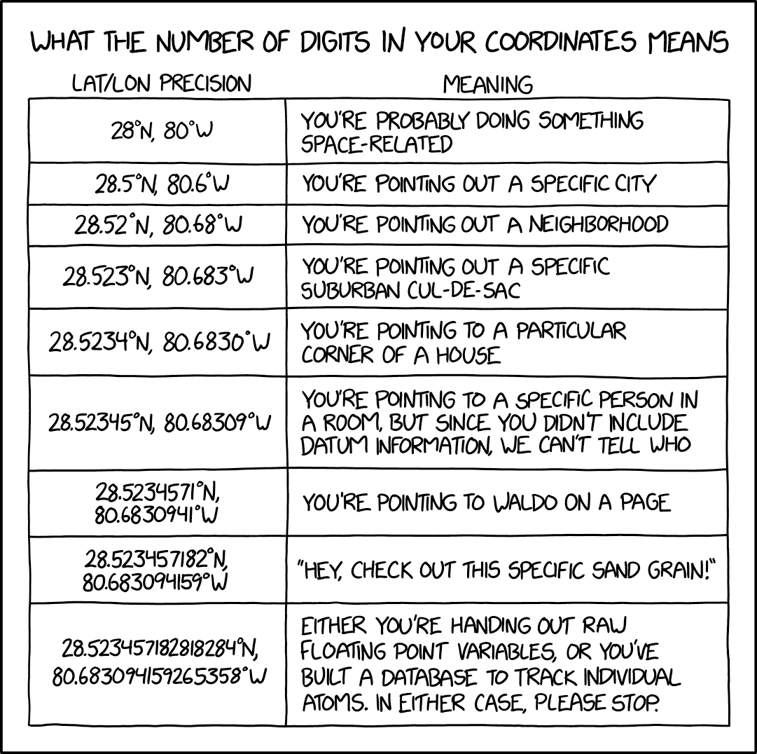
In Monday’s xckd, Randall Munroe points out that when it comes to coordinate precision, there is such a thing as too many decimal places.
The Return of ‘Map Men’
After a hiatus of more than two and a half years, Jay Foreman and Mark Cooper-Jones are back to producing new episodes of Map Men. Back in 2016 I called the series “two silly people being very smart about often-silly cartographical situations” (though I may have gotten that backward). Anyway, they’re back, with episodes on the geological origins of the English-Scottish border and trap streets.
xckd’s ‘Least Informative’ Google Trends Maps
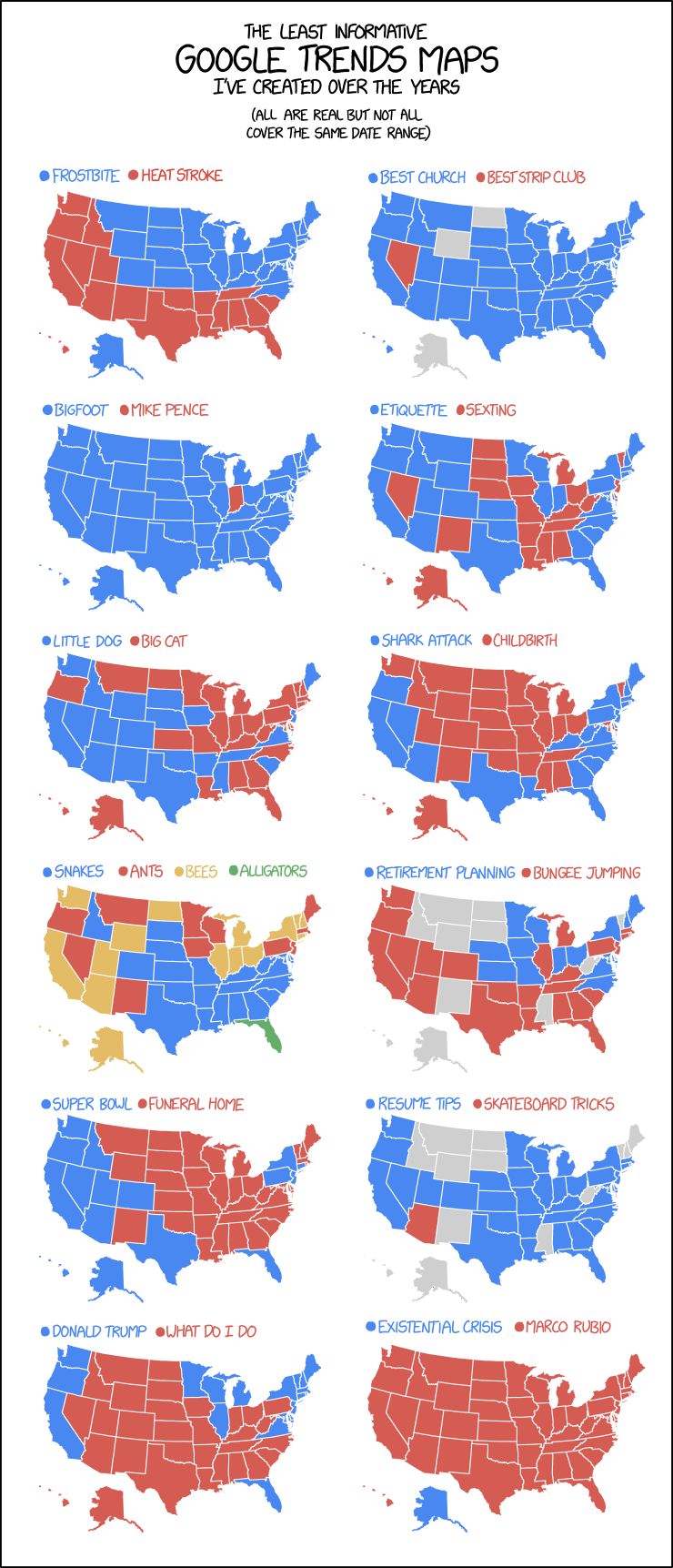
Oh look, another map-themed comic/infographic thingy from xkcd: the March 20 edition is having some fun with the maps generated by Google Trends data. The maps are real, says Randall.
Pop vs. Soda Maps Spoofed by xkcd
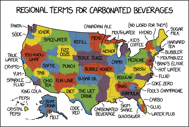
By law, I am required to share every xkcd comic about maps. Today’s makes great fun of pop versus soda maps—the maps showing where in the U.S. carbonated beverages are referred to as pop versus where they’re referred to as soda. Randall takes things to their ludicrous extremes, as he is, by law, required to do.
Itchy Feet’s Map of Every American City

Itchy Feet cartoonist Malachi Rempen gives us a sequel to his “Map of Every European City”: the equally true and accurate “Map of Every American City.”
Previously: Itchy Feet’s Map of Every European City.
Itchy Feet’s Map of Every European City

The latest cartoon from Itchy Feet, a comic about travel and language by filmmaker Malachi Rempen, is a “Map of Every European City.” In the comments, the cartoonist says, “Having been to every single European city, I can safely say with confidence that they all look exactly like this.” I don’t think he’s wrong.
Name a Country, Any Country
Last week, Jimmy Kimmel Live had a skit where they asked passersby to name a country, any country, on a map of the world. The results were predictable—doofs who couldn’t name any country at all, or who thought Africa was a country—and so has been the general reaction. Americans not knowing their geography is a cliché that’s decades old at least. Thing is, the half-dozen or so people being shown aren’t a representative sample: the aim here isn’t a scientific survey, it’s good television. And laughing at idiots counts as good TV in America. In that vein, the kid going all Yakko’s World at the end is an absolutely necessary punchline. [Cartophilia]
Map Men
Map Men is a YouTube series by comedians Jay Foreman and Mark Cooper-Jones. It’s funny as hell, and quite informative too: it’s two silly people being very smart about often-silly cartographical situations. Six episodes so far; I hope they make more. [Geographical]