
The 30th International Conference on the History of Cartography will take place the first week of July 2024 in Lyon, France. Its theme is “Confluences—Interdisciplinarity and New Challenges in the History of Cartography.” The call for papers is open until 20 November 2023. Two associated exhibitions have already been announced, one on distant spaces, the other on maps and images of travel.
What3Words Confusion Rate Under Scrutiny
The What3Words geocoding service assigns a three-word mapcode to every three-square-metre patch on the planet, the premise being that three words are easier to remember and share than longitude and latitude to the equivalent decimal places. But the main complaint about What3Words (apart from the proprietary nature of its algorithm and database) is that it’s possible to get even those three words confused, especially in contexts where plurals and homophones may not be heard clearly, or where similar combinations of words are close enough to each other that they can be mistaken for each other. There’s actually an entire website dedicated to chronicling errors in W3W.
W3W maintains that their algorithm keeps similar combinations “so far apart that an error is obvious. We also worked hard to remove homophones and near homophones like sale and sail.” They rate the the chance of two confusing combinations appearing close enough to be unclear at about 1 in 2.5 million. But in a new analysis of the algorithm, currently in preprint, computer scientist Rudy Arthur argues that despite W3W’s claims this chance of confusion is far higher, and warns against adopting W3W as critical infrastructure (it’s used by emergency services, particularly in the U.K.) without testing and comparing against available alternatives. [The Register]
Previously: What3Words Hasn’t Had the Greatest Couple of Months: A Roundup.
New York and Philadelphia Regional Rail Networks on One Map

Here’s a rail network map that shows the commuter rail lines of both New York City and Philadelphia. It’s by Evelyn Ivy, who explains on Mastodon that it took six months of work to complete. “Showing five different commuter rail systems (#CTRail, #MetroNorth, #LIRR, #NJTransit, and #SEPTA), this map depicts everywhere a passenger can get to by train from NYC or Philadelphia without using Amtrak.” (The keys are Trenton and New Haven, where you can hop from one system to the next.)
Star Wars and Its Obsession with Maps

The first two episodes of the latest Star Wars series, Ahsoka (which launched this week), focus on the struggle to acquire, unlock and interpret a map to an unknown destination. Sound familiar? It should: The Force Awakens did something awfully similar. Gizmodo’s James Whitbrook explores Star Wars’ apparent map obsession, and concludes it’s about knowledge, and how easily it’s lost. “And that’s it, really: maps are important in Star Wars because knowledge is power in Star Wars as much as a Death Star or the Force is. And specifically in the case of a long, long time ago, archival knowledge and history is incredibly vital to understanding why Star Wars is the way it is.”
Previously: Mapping Star Wars.
Can Places on Google Maps Be Trusted?
Google has been plagued with fraudulent and scammy business listings on Google Maps for years (1, 2). Last April, Google posted about the steps it takes to combat fake content. James Killick points to more recent incidents and wonders whether places on Google Maps can still be trusted; given that he was able to add a fake listing and have it appear on the map within hours, signs point to no.
Upcoming Leventhal Exhibition Will Explore Boston Transit Maps
An upcoming exhibition at the Boston Public Library’s Leventhal Map Center, Getting Around Town: Four Centuries of Mapping Boston in Transit, “brings together an extraordinary collection of maps, plans, ephemera, and other materials to investigate how Bostonians have moved around the city in the past, present, and future.” Opens September 9 and runs until April 27, 2024. Free admission.
The Origins of U.S. County Names
Curious about the origins of American place names, Lia Prins built a dataset of U.S. county names and categorized them by what they’re named for and the language they’re named in. There’s an interactive map, detailed inset maps showing how names types are clustered, and a discussion of methodology. [Maps Mania]
National Library of Israel Receives Donation of 400+ Antique Maps

More than 400 maps, previously owned by collector Howard I. Golden, have been donated to the National Library of Israel.
The antique maps, dating from 1475 to 1800, were preserved in excellent physical condition by Mr. Golden who, over several decades, collected historical maps of the Land of Israel. A significant percentage of the maps were printed before 1700 and are therefore defined as rare. NLI has cataloged and digitized the maps for preservation and research purposes, to be used as primary sources, downloadable and free-of-charge, for students, researchers, and visitors from Israel and abroad.
The library’s map collection is available online. News coverage from The Times of Israel.
The Routledge Handbook of Geospatial Technologies and Society
 Out this week: The Routledge Handbook of Geospatial Technologies and Society (Routledge), a collection of essays edited by Alexander J. Kent and Doug Specht. “Contributors reflect on the changing role of geospatial technologies in society and highlight new applications that represent transformative directions in society and point towards new horizons. Furthermore, they encourage dialogue across disciplines to bring new theoretical perspectives on geospatial technologies, from neurology to heritage studies.” Via Matthew Edney, who’s got a chapter in it on pre-1884 geospatial technology. Amazon (Canada, UK), Bookshop.
Kent previously co-edited The Routledge Handbook of Mapping and Cartography (Routledge, 2017) with Peter Vujakovic (previously), and co-authored The Red Atlas (University of Chicago Press, 2017) with John Davies (my review).
Maps Reveal Extent of Land Privatization in Traditional Territories
New maps show the extent to which the Saskatchewan government has been privatizing or leasing public land near indigenous reserves. First Nations in the province are unhappy to discover that those lands—the subject of ongoing negotiations with the government—are no longer available for their traditional use. CBC Saskatchewan has the story (also see video above; the centre responsible for the maps has not posted them online).
Adam Savage, Paper Maps and the Thomas Guide
In a 15-minute video posted to YouTube, Adam Savage ruminates on the advantages of paper maps, the Los Angeles institution that was the Thomas Guide, and navigating by paper map in general (with digressions on the Knowledge and trap streets and such).
Previously: The Rise and Fall of the Thomas Guide.
‘Whoops, Made All Longitudes Positive’
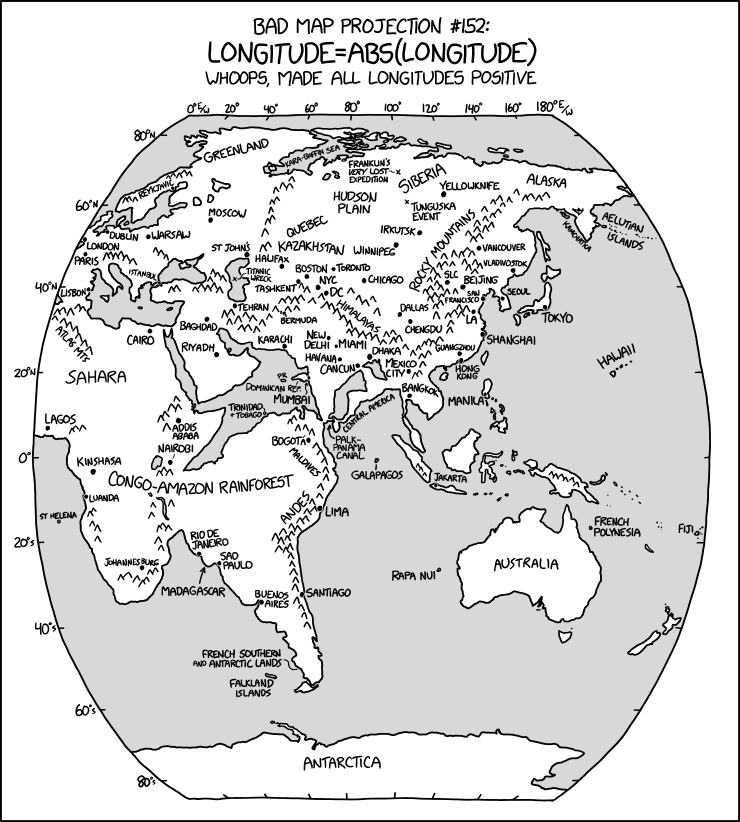
The latest in Randall Munroe’s Bad Map Projection series on xkcd is perhaps his most evil yet: it turns all longitudes positive—i.e., it turns west longitude into east longitude, putting Quebec somewhere in Kazakhstan and the Panama Canal off Sri Lanka.
The Aftermath of the Kakhovka Dam’s Destruction

NASA Earth Observatory has before-and-after satellite imagery showing the impact of the destruction of Ukraine’s Kakhovka Dam last month. The Kakhovka Reservoir is emptying out (above), the irrigation canals that relied on that reservoir are drying out, and there was flooding downriver of the dam in the immediate aftermath of the breach.
Apple Maps Roundup for July 2023
Downloadable maps are coming to Apple Maps in iOS 17 this fall. Ars Technica looks at how they’ll work, and how they’ll compare to Google Maps’ offline maps (at the moment—which to be sure is with the iOS 17 public beta—Apple’s offline maps take up much more space but also offer more detail).
James Killick considers Apple’s forthcoming Vision Pro headset and wonders whether something might not be afoot in the mapping space. “The real kicker for geospatial is its ability to immerse you in a truly 3D experience. […] So given a truly immersive 3D experience is possible, think of the wonders it will do for maps and mapping in general.”
After expanding its new maps to central Europe—Austria, Croatia, Czechia, Hungary, Poland and Slovenia—in April, Apple brought detailed city maps to Paris, cycling directions to the whole of France, and its new maps to Hong Kong, Taiwan and Slovakia in June. As usual, Justin O’Beirne has all the details at the above links.
California (Mapped by) Typewriter
 Anything mashing up maps and typewriters is guaranteed to get my attention (I have 37 of the latter and rather a lot more of the former). So I have no choice but to share R. J. Andrews’s “Typewriter,” an elevation map of California created on a manual typewriter.
Created by layering combinations of nearly 2,500 keystrokes (I, H, X, and O) with a 1953 Royal Quiet De Luxe typewriter on Masa 77gsm paper from Japan. Based on a California Albers projection at approximately 1:5,000,000 scale.