Skip to content

The Map Room

  • About
    • Contact
    • Privacy Policy
  • Archives
  • Books
    • Map Books of 2025
    • Book Reviews (2011-present)
    • Older Book Reviews (2006-2011)
  • Extras
    • Blogroll
    • Fantasy Maps
    • Fiction About Maps
    • Publications
  • Subscribe & Follow
    • Email Digest
    • Bluesky
    • Facebook Page
    • Mastodon
    • RSS Feed
  • Patreon

Mapping Infinite Jest

Published on 7 September 201222 October 2017 by Jonathan Crowe

Infinite Map 
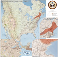
Online and print versions of a map of David Foster Wallace’s 1996 novel Infinite Jest are now available, the latter for purchase. Both are part of William Beutler’s Infinite Atlas Project, “an independent research and art project seeking to identify, place and describe every possible location in David Foster Wallace’s Infinite Jest.” Via AppNewser and Kottke.

Link•Categories Maps and Literature

Post navigation

Previous Mapping Hurricane Tracks
Next Dung Kai-cheung’s Atlas

About The Map Room

The Map Room is a blog about maps by Jonathan Crowe. Since 2003 he has covered everything from antique map collecting to the latest in geospatial technology. More about The Map Room.

Subscribe and Follow

  • Email Digest
  • Bluesky
  • Facebook
  • Mastodon
  • RSS Feed

Support The Map Room

The Map Room is now ad-free thanks to the support of readers like you! Join them by becoming a member at Patreon.

Affiliate Disclosure

The Map Room participates in the Amazon, Bookshop and iTunes affiliate programs. I earn income from qualifying purchases made through links on this website.

A collage of book covers: some books about maps scheduled to appear in 2025.

Archives by Month

Categories

Tags

1500s (46) 1800s (33) Apple (50) Apple Maps (79) books (321) California (32) Canada (106) cities (173) climate change (47) comics (40) coronavirus (50) COVID-19 (52) data visualizations (34) disease (42) elections (53) exhibitions (145) fantasy map design (37) fantasy maps (133) fun (42) funny (80) global warming (36) globes (64) Google (68) Google Maps (121) history of cartography (58) iOS (60) iPhone (43) libraries (134) London (65) map design (45) map projections (55) NASA (64) New York City (42) New York Times (39) OpenStreetMap (35) pictorial maps (38) railroads (35) railways (35) satellite (40) satellite imagery (52) tube (32) UK (75) USA (185) wildfires (38) xkcd (40)
Privacy & Cookies: This site uses cookies. By continuing to use this website, you agree to their use.
To find out more, including how to control cookies, see here: Cookie Policy
Proudly powered by WordPress | Theme: Toujours by Automattic.